On 24 January, the Workshop to launch the ODYSSEA Al Hoceima Marine Observatory project was held at the Faculty of Science and Technology in Al Hoceima. The event was organized by the Association AGIR in partnership with the High Commissioner for Water and Forests and the Fight against Desertification (HCEFLCD), the National Institute for Fisheries Research (INRH) and with the participation of a representative from the Tangiers-Tetouan-Al Hoceima region, the Secretariat of State for Sustainable Development – through its National Environment Laboratory and its Environment Observatory in the Tangier region -, the Maritime Fisheries Delegation, the National Maritime Fisheries Office and a representation of cooperatives and artisanal fishermen’s associations in the region.
On Thursday 24 January, at the Faculty of Science and Technology of the city, the workshop to launch the ODYSSEA-Al Hoceima Marine Observatory Project entitled « Technological Exploitation of a Network of Integrated Mediterranean Observatory Systems for a Blue Economy in Al Hoceima » was held. Thanks to this project funded by the European Union to the tune of 8,300,000 euros , Morocco will soon be able to guarantee access to high-precision oceanographic, biological and climatological data collected within its territory by a wide range of users and users.
The Al Hoceima Observatory will be one of the 9 Mediterranean Observatories set up as part of the ODYSSEA project. It should be noted that the Al Hoceima observatory will immediately comply with the best international standards in terms of equipment – estimated at one million euros– management and performance.
Real-time monitoring of biodiversity and resources
T he ODYSSEA project platform based in Al-Hoceima aims to contribute to the implementation of the blue economy concept by providing relevant and usable Mediterranean marine data to a wide range of end users. Example of students and researchers affiliated to the various Moroccan universities who will be able to analyse the data according to various scientific themes (integrated coastal zone management, data modelling, etc.).
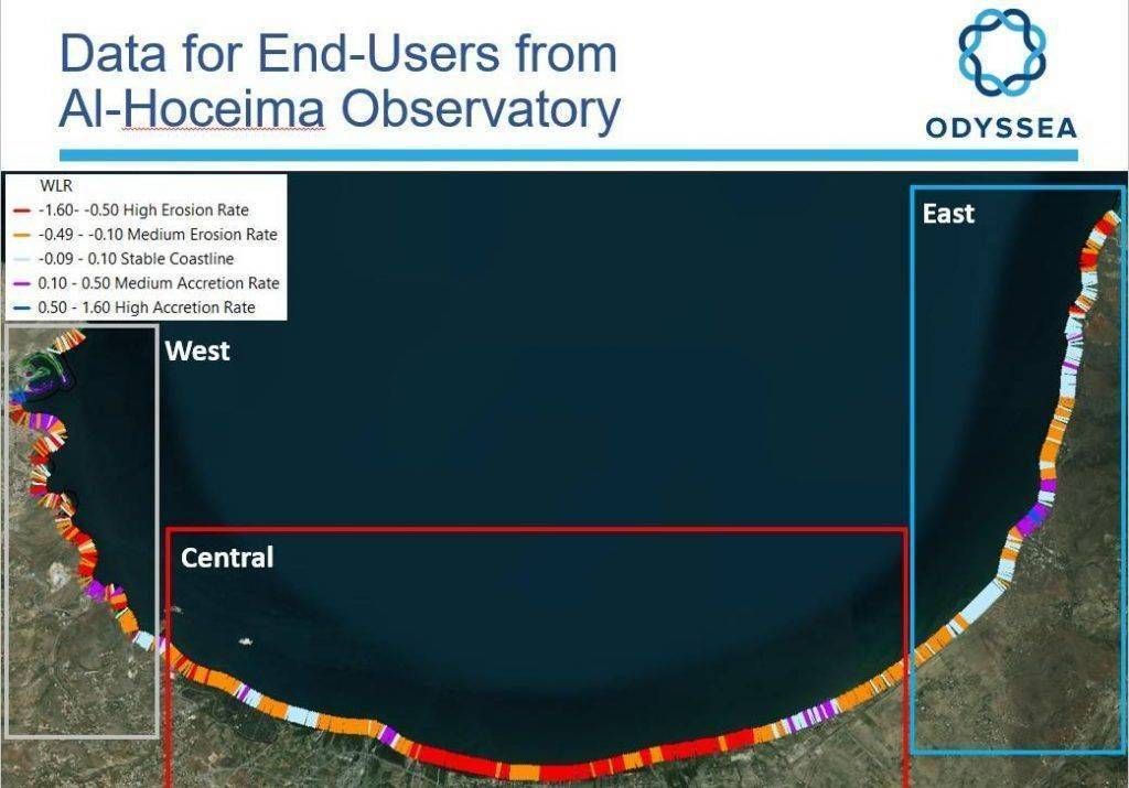
Another example is that of urban users concerned with mapping and predictions related to coastal sites least affected by erosion phenomena, not to mention marine biodiversity and fisheries resource managers who will have tool levels at their disposal to optimize innovative and adaptive management within the Al Hoceima National Park.
Mr. Slim Gana of the Regional Activity Centre for Specially Protected Areas RAC/SPA (partner of HCEFLCD and AGIR) specified in this respect that a training programme will be provided for the benefit of the various ODYSSEA users so that they become familiar with and appropriate the use of the platform.

Making fishing more sustainable and optimising aquaculture
ODYSSEA Al-Hoceima data will benefit the approximately 3500 fishermen who are active in the province. Allowing them to anticipate the risks of bad weather, to reduce fishing efforts for better catches, more profitability and sustainability of their fishing gear.Also, in a context of climate change, this project will better strengthen the adaptation and rapid response mechanisms of users . Port authorities will be provided with timely and instantaneous data on salinity and density to calculate the buoyancy of cargo vessels in order to optimize port entry time.
Mussel operators will benefit from marine and meteorological data to select the most appropriate installation sites and help them protect them through alerts of approaching toxic algal blooms or heat waves affecting mussel growth. With the increasingly noticeable appearance of jellyfish and even physalies, swimmers will always be one step ahead thanks to the real-time monitoring provided by ODYSSEA.
These are just a few examples of users who will be able to improve their safety and performance thanks to access to data collected within the Al Hoceima observatory by the various fixed, surface and depth sensors and other pre-programmed mobile devices that make traditional techniques almost obsolete. During this workshop, several speakers expressed their strong interest in the multidisciplinary project, and their desire to make it an example of integrated and innovative management.
Align with the highest technological standards
According to Dr Benyounes Abdellaoui, head of the INRH oceanographic laboratory in Tangier, this experiment would also enable Morocco to become more autonomous by moving from the use of low-quality open source data often collected from third parties to the use of real-time and highly accurate data.
For Georgios Georgios SYLAIOS Professor at the University of Thrace Department of Environmental Engineering and Director of the Laboratory of Ecological Engineering and Technology:
Only this degree of precision makes it possible to build precise models worthy of decision making for reliable management!

Mr. Idrissi Mallouli, Head of the Mediterranean cluster at INRH, proposed to ODYSSEA focal points to extend its services throughout the Mediterranean. To which Mr. Nibani Houcine replied:
Odyssea’s success in Al Hoceima would open this path even on the Atlantic side.
Like the Tangier observatory, ODYSSEA will provide the High Commission with a range of evolving and real-time indicators in the marine area of the Al Hoceima National Park. As for the laboratory of the Secretary of State for Sustainable Development, this project will allow it to monitor beach health in real time. It should be noted that the ODYSSEA project will be managed by the Association AGIR in partnership with HCEFLCD and INRH.
Finally, Mr. Ezzahidi Hicham, Regional Director of Water and Forests in Al Hoceima, expressed the wish to see the ODYSSEA project completed as soon as possible. Mr. Nibani also announced that the necessary devices and equipment will be installed as of next April:
The services that the observatory can provide will therefore be functional!
 Ecologie.ma


